 Karen Rubin")
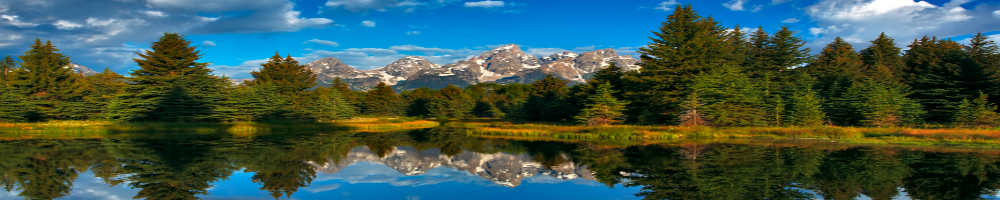
New York State’s Hudson River © 2013 Karen Rubin/news-photos-features.com
For the first time in 100 years, the public can now access for recreational purposes the Hudson and Cedar Rivers within 7200 acres of new lands recently added to New York State’s Forest Preserve.
Parking areas, public motor vehicle access, a hiking route to the Cedar River and waterway access sites for non-motorized watercraft are designated and available for public use on these newly acquired public lands in the Towns of Newcomb and Minerva in Essex County and Indian Lake in Hamilton County.
Signs and kiosks located at both the Boat Launch in Newcomb and on the newly acquired properties provide information about the lands and the premier paddling and fishing opportunities now open to the public along the Hudson and Cedar Rivers. A map depicting the lands that are currently open to the public; the location of parking areas, public motor vehicle access and hiking routes and waterway access sites is posted on signs and information kiosks and is also available on DEC’s website at www.dec.ny.gov
The public access currently provided through the Interim Access Plan is temporary, allowing the public to enjoy the lands this summer and fall prior to the final classification of the lands by the Adirondack Park Agency. The Interim Access Plan does not in any way influence or predict the result of classification process. Public access and recreational opportunities have been outlined in an Interim Access Plan for the Hudson and Cedar Rivers and surrounding lands, available on the DEC website.
“This is the first step in providing public access to these lands, which may bring additional tourism revenues to our community and the region,” said Brian Welles, Supervisor of the Town of Indian Lake. “Future public access will be determined by the land classification and the unit management plan. I encourage all to participate in the public review process, provide comment and attend one of the APA classification meetings, such as the one scheduled in Indian Lake on June 25.”
The APA has proposed seven possible land classifications for the Essex Chain Tract and surrounding lands. The proposed land classifications and the schedule for public comment may be found on the APA web site: http://www.apa.ny.gov/.
Public access facilities outlined in the interim plan have been established where existing areas are cleared and infrastructure is already in place. Recreation users will need to follow existing paths to carry around rapids when traveling down the Hudson River and camping is allowed more than 150 feet from any road, trail, spring, stream, pond or other body of water. Marked trails, camping sites and portages will be designated and constructed once DEC, in consultation with APA, completes a Stewardship Plan later this summer. This Stewardship Plan will identify the location for a new trail for the public to safely access OK Slip Falls, designated camping sites along the Hudson and Cedar Rivers, and the official locations of portages around challenging stretches of the Hudson River for paddlers.
Upper Hudson River
Paddlers can travel nearly 12 miles on the Hudson River from Harris Lake to a landing just above the confluence with the Indian River. There are several stretches of flat but moving waters that people of all skill levels can enjoy, especially in the upper portion.
The river also contains numerous rapids and shallow rocky areas. Depending on water levels, the rapids are mostly rated Class 1, 2 or 2+. Under the certain water levels a few of the rapids may rate Class 3, such as Long Rapids and Ord Falls. During low water conditions a considerable amount of portaging, dragging and lining of kayaks and canoes will be required especially in the lower portion of the river.
Less adventurous paddlers can take advantage of a long stretch of flat water above and below 28N, and the Blackwell Stillwater section above and below the Iron Bridge Landing, which also provides access to the lower Goodnow River.
Trips shorter than the entire 12 miles can be taken by paddling from Harris Lake to the Iron Bridge Landing or from the Iron Bridge Landing to the Indian River Landing. Inexperienced paddlers should make use of the flatwater sections, carry around all rapids or hire a licensed guide to lead their trip.
The flatwater sections also provide for good fishing opportunities for smallmouth bass, northern pike and panfish. In the stretch just south of Route 28N anglers may find walleye and an occasional largemouth bass. The Hudson River between the Cedar River and the Indian River also contains brown and rainbow trout.
The Town of Newcomb Boat Launch on the Harris Lake (Beach) Road is the best location to launch canoes, kayaks and rafts. Parking is available at this location and in the nearby parking lot at the Town of Newcomb Beach. Information about the available access, including maps, is provided on a kiosk at the boat launch.
The public can drive to a parking area located approximately 0.9 mile from the Iron Bridge Landing. Paddlers need to carry their canoes and kayaks between the parking area and the landing on the river. Information about the available access, including maps, is provided on a kiosk at the parking area.
The Iron Bridge parking area can be reached by taking the Goodnow Road, off Route 28N in Newcomb, approximately 5.5 miles south to the southeast corner of Goodnow Flow. Turn left on to the access road and the parking area is two miles away at the end of the access road. DEC recommends that only high clearance pickups and SUVs use the roadway at this time.
Another parking area is located at the end of the Chain Lakes Road, approximately three miles north of Route 28 in Indian Lake. The public can walk the 0.8 mile on the roadway between the gate at the parking areas and the landing above the confluence of the Hudson and Indian Rivers. Information about the available access, including maps, is provided on a kiosk at the parking area.
Cedar River
The Cedar River, Pine Lake, Mud Pond, Clear Pond, Corner Pond and the surrounding lands can all be accessed from the same parking area at the end of the Chain Lakes Road. It is a 3.5-mile walk from the parking area along a roadway to the landing on the Cedar River.
Paddlers can enjoy the flatwater section of the Cedar River above and below the landing. The rapids above and below the flatwater section and the lack of carries prevents paddlers from accessing the upper reaches of the Cedar River and the Hudson River from the landing. Paddlers can also enjoy the four ponds on the forest preserve lands south of the Cedar River.
Anglers can fish the Cedar River for brook and brown trout. Anglers can also fish for native lake trout and stocked rainbow trout on Clear Pond or stocked brook trout and panfish on Pine Lake. Float planes previously restricted to landing on the western portion of Pine Lake can now land anywhere on the lake.
Additional information on the recreational opportunities on these and other nearby forest preserve and conservation easement lands can be found on the DEC Eastern Adirondacks Trail Information web page at http://www.dec.ny.gov/outdoor/9199.html.
APA Chairwoman Lani Ulrich said, “We applaud the Department of Environmental Conservation for their efforts to get these remarkable lands open to the public in time for the summer season. This truly is a historic land acquisition that will have long lasting positive impacts on the environment and economy of the Adirondack Park. The Agency eagerly anticipates conducting the scheduled public hearings to solicit public input regarding proposed state land classifications. These hearings are an important step to establish public access and we encourage citizens to voice their positions. ”
The Essex Chain Lakes Tract and the Indian River Tract are part of the former Finch, Pruyn & Co. lands purchased by New York State from The Nature Conservancy (TNC).
For more travel features, visit:
www.examiner.com/eclectic-travel-in-national/karen-rubin
www.examiner.com/international-travel-in-national/karen-rubin
travelwritersmagazine.com/TravelFeaturesSyndicate
‘Like’ us on facebook.com/NewsPhotoFeatures
Twitter: @TravelFeatures
